|
STRAWBERRY MINE, CA, FIELD TRIP - SEPTEMBER 18-20, 2009 |

|
Strawberry Mine Itineraryby Lee McIlvaineSuggested Route: From the South Bay I would recommend traveling on Rt 152 east to 99 south to Madera exit for RT 145 east just north of Fresno. Note there are a few turns in Madera to get onto 145 East. Take 145 east to 41 north. There is a Valero Gas station on route 41 north, this has the cheapest gas in the area. No more than a few miles north of the Valero station on Rt 41 turn right onto Road 200 at a traffic light. Follow Road 200 into the town of Nork Fork (~about 15 miles) The road name will change to Road 222/North Fork Rd, and eventually Road 225/Minarets Rd, however just stay on the main road into North Fork. In North Fork there is a Chevron Station. This is your last chance to fill up with gas. Less than 1/2 mi past the Chevron on the east side of town is NorkFork Super Market on the left. This route is less curvy than going on Route 49 and 41 south at Oakhurst. Buckhorn is a good place to eat across from the Chevron Station if you are hungry on your way out on Sunday. Friday Meeting Place: Parking Lot of the NorkFork Super Market at 5pm. The address of the Super Market is 57027 Road 225, NorkFork, Ca 93643. maps.google.com shows address a little east of the actual location of the Market. It is on the corner of Road 225 and Road 8017. We will need to leave by 5:30 in order to drive the 1-1.5 hrs to the camping area and allow time to setup before dark. If you get caught in traffic or miss the meeting time just continue on Road 225/ Minarets Rd past the NorthFork Market. More detailed instructions are provided below. Saturday Meeting Place: Lower Gate of Strawberry Mine at 11am. Directions From the NorkFork Market are as follows. Continue east on Road 225/Minarets Road. This road goes past a few small residential areas and a trailer park. In a few miles the road will get smaller and narrower up to the Start of the Scenic Byway. Note there are a few sharp bends. You want to follow signs along the Scenic Byway to Clover Meadow (about 50 miles). You will see a sign indicating no access to Yosemite or Rt 395. You can stop at the Mile High Overlook for a photo and a bathroom break (about 1/2 half way). At the end of the paved road GO RIGHT toward Clover Meadow. The left turn continues on the Scenic byway and loops back west toward NorkFork. Continue for a few miles on the dirt road to Clover Meadow. This stretch of road is wash-boarded in several places and is a little rough so you will need to keep the speed down. Clover Meadow will be on your left. You will see a small cabin, a white trailer, an antenna in a the grassy area and maybe a car or two. Continue on past Clover Meadow and KEEP LEFT, there is a small road that forks off to the right. The road becomes Forest service road 5S30 (no signs). To Camping Area: In about 0.5 to 1 mile past Clover Meadow there will be a road that goes off to the left and almost doubles back. This road then runs parallels Granite creek to the area where we will likely be camping. This road is the old entrance into the Strawberry Mine, but the old bridge washed out many years ago. The area has become a camping spot, but is not named on any maps. Alternate camping areas will be Clover Meadow or Granite Creek Campground which are a few miles from the mine. Granite creek will likely be dry or nearly so, and we can look along the creek as well for specimens. If you continue too far on 5S30 it becomes road 4S43 and will go to the new Bridge across granite creek. This is the route to the Strawberry Mine.
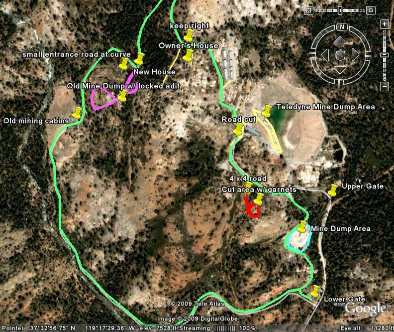
To Strawberry Mine: Continue past the left turn to camping area. In less than 1 mile you will cross Granite Creek on a small concrete bridge. The road forks on the other side, Stay LEFT. There is a sign to the Strawberry Mine. Continue on this road through the open forest service gate and up a straight, gentle grade. The Lower Gate will be on your left. This is where we will enter the mine property. If you continue past the Lower Gate by accident you will come to a fork in the road. The left fork goes to the upper gate. You will need to turn around and go back to the lower gate. This is where We will meet on Saturday at 11am. Note the gate opens toward the road so leave enough room for it to swing open. If you arrive at a different time than 11am on Saturday. I will hide a key under a rock near the Lower Gate. The rock is fist sized and is located on the right side of the gate and about the distance the gate swings open toward the road (10-12 ft)at 90 degrees from the closed position. The rock has faint orange spray paint on top. Please open the gate drive through, close and lock the gate, and return the key to under the rock. This will allow all to come and go as needed. On the attached map there are 3 main dump areas. We will most likely be at one of these on Saturday. The garnet area in red is up a short 4x4 road in a cut in the hillside. We will also make a short visit to this location. It is visible from the main loop road shown in green. VERY IMPORTANT: We need to avoid leaving the gate open. We do not want other hikers in the area to drive in and get trapped inside without the ability to get out. I will grab the key after we all depart on Sunday. Please call me with any questions 510.325.0082. Cell phone coverage is spotty after the NorkFork Super Market and gets progessively worse. I am told there is one high spot north of Clover Meadow and south of the lower gate where most cell phones do receive a signal. | |