|
CHAMPION MINE - DIRECTIONS & WHAT TO BRING |

|
|
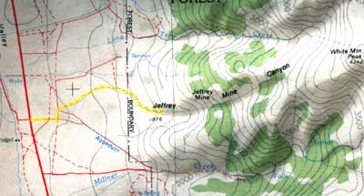
Directions The Champion Mine is located near the Navada Border southeast of Mono Lake. From the North. Proceed on Highway 395 until you are just south of Mono Lake. Turn left on Highway 120 and proceed until you intersect Highway 6, at Benton (also known as Benton Station). Turn right (south) on Highway 6. The White Mountains are the range on your left and White Mountain is one of its peaks. Go approximately 15 miles and turn left (east) on the White Mountain Ranch Road. Turn left at the the pump house and then right at the second road (see map). This road will swing around and enter Jeffery Mine Canyon. Proceed up the canyon to the end of the road. You should be able to drive to the old mule corrals and most people leave their cars there. From the South. Proceed on Highway 395 to Bishop and then proceed north on Highway 6 about 20 miles. The White Mountains are the range on your right and White Mountain is one of its peaks. At about the 20 mile mark, you will come to the White Mountain Ranch Road on the right. Turn onto this road and then turn left at the the pump house and then right at the second road (see map). This road will swing around and enter Jeffery Mine Canyon. Proceed up the canyon to the end of the road. You should be able to drive to the old mule corrals and most people leave their cars there. From Navada. Approach by Highway 6. When you come to Benton, follow the directions from the north (above). If you need a comfortable staging area to meet, a good place is the Cafe in Benton (also known as Benton Station), at the junction of Highways 120 and 6.
At the mule corrals, you have two choices.
(1)The trail head for the old mule trail is self evident. The trail rises about 2,000 feet to a group of cabins you can use as a base camp. Once you are on the trail, it is almost impossible to miss your way. There is a bad place where the trail is washed out where it crosses the creek. Make your way around the small slide near the creek. You can use existing paths to more or less follow the creek and will soon strike the undamaged trail. Proceed up to the cabins.
(2)There is a "road" which goes up the ridge to the north. Although this takes you north of the bench with the cabins, when you get to the level of the cabins, you will find a trail that goes directly there. This route is somewhat longer but easier going.
The base camp is a living museum tended by those who collect at the mine. Act accordingly. Please leave it in better condition than you find it and pack your non-degradable garbage back out.
The key to survival on White Mountain is to take it easy and watch your footing. You will be working at an elevation of around 7,000 feet, so pace yourself and travel light. The trails to the mines rise about 2,000 feet to the upper workings and are apt to be chancy. There are almost always new washouts or slides to be dealt with, but you can always see the trend of the trail and proceed to link up with it. The trails were made for mules to carry heavy loads up a steep mountainside and you would be smart to follow them.
What To Bring
It is a strenuous climb in and out, so keep your gear to a minimum. Don't take too much ironmongery, a g-pick and a baby sledge is plenty. Remember that a 2 1/2 pound hammer on a 30" handle is more effective than a 4 pound hammer on a short handle. Use food packaging and clothing to wrap specimens and use a frame pack so the rocks don't poke you in the back and both your ands are free in the event you loose your footing.
As far as clothing is concerned, the weather is extremely variable and anything can happen. Usually it is dry and warm with cool nights. I would take long pants (some of the vegetation is unfriendly) and ankle high boots (lots of loose small rocks in some areas) with
moccasins or something similar to change into in camp. A jacket and long sleeved shirt are good to have as mornings and evenings can be cool. I is not likely that really bad weather will hit at this time of year but a day of bad weather is possible. The sunlight can be intense, so bring a hat and sun screen.
As far as food goes, the lighter the better. Anything suitable for backpacking would work well. Its amazing how climbing around at 8,000 feet can whet your appetite. In general there are a number of packaged macaroni or rice products that can supply bulk to dinners (a hot meat is real nice at the end of the day) and packaged oatmeal or a package of sweet rolls is a good breakfast. Fruit, though heavy, is always welcome as a break and oranges or apples can be carried up without worry. Rolls work better than bread and lunch meat and cheese make good lunches. Don't depend on canned food and except for a few things fresh stuff is too heavy and perishable. Take sugar sweetened Kool Aid and leave the sodas in the car. Don't forget the toilet paper. The best way to approach the food is for several people to plan a menu and that way more variety is possible and weight won't be as much a factor.
Normally, the water in the creek is good and that is what most people up there use. If the year has been dry the water can get real yucky, but its still drinkable. Kool Aid helps to cut the taste and works as a flocculating agent. How I don't know, but the results need to be seen to
be believed. Mix the water and Kool Aid and let stand for about 10+ hours, then decant. If you are nervous about your water, bring along some water purifying tablets.
Good Luck. If you find that conditions have changed substantially, please drop us a line and we will post your information.
| |